
![browns_ferry[1].JPG](https://images.squarespace-cdn.com/content/v1/5c2d231b50a54ff28d396220/1549399502812-WPU3R2R7IEOZ8DS7XOTK/browns_ferry%5B1%5D.JPG)
TVA Browns Ferry Nuclear Power Plant
The Browns Ferry Power Plant is located on the north bank of the Tennessee River, to the NW of Morgan County. Even though the plant is located in another county, we have plans & procedures that are practiced yearly to always be prepare. If there is ever an incident at Browns Ferry Power Plant, TVA will notify the state and local officials at once. Then the local officials will notify the public.
There is a Prompt Notification System in existence. This system is the primary means to notify the public. This system utilizes sirens and the distribution of information through radio, television, Emergency Alert System messaging and the NOAA weather radio messaging.
There are sirens located within the 10-mile radius of the plant to alert the public. These sirens can also be used to alert the public of floods, tornadoes and other natural or man-made disasters. You should always go inside and listen to your television, radio and NOAA weather radio, if you ever hear a siren sound a long steady sound, to listen for further information. There will be additional information on one of these means of communication. Do not call 911 for information if you hear the sirens. Then check on your neighbor and stay off the phone unless it is absolutely an emergency.
Please keep in mind that we test the sirens every month on the second Monday at 9:15 A.M, unless there is severe weather.
You can find the Sector that you live or work in, in the above tab “Sector Map”. Then locate in the above, Evacuation Tab, which route that you will take if there is an order to evacuate. The Reception Center Tab will give you the location of the centers where you need to go to register as an evacuee. It is important that you register for accountability. Please use the above tabs for more information.

hOW BROWNS FERRY WORKS
Browns Ferry Nuclear Power Plant was named after a ferry in Lawrence County, Ala., at the crossing of the Browns Ferry Road from Huntsville to Courtland, Ala. The North Alabama ferry was originally operated by the Cherokee family of John Brown and historically recorded as being used as early as November 1813 by local Cherokee Cuttyatoy. John Brown's daughter Patsy married Captain John D. Chisholm who acted as an attorney for Chickamauga Chief Doublehead who lived at Doublehead's Town at Browns Ferry. Betsy, another daughter of John Brown, married a Cox and for a short period the ferry was called Cox's Ferry, but it later reverted back to Browns Ferry.
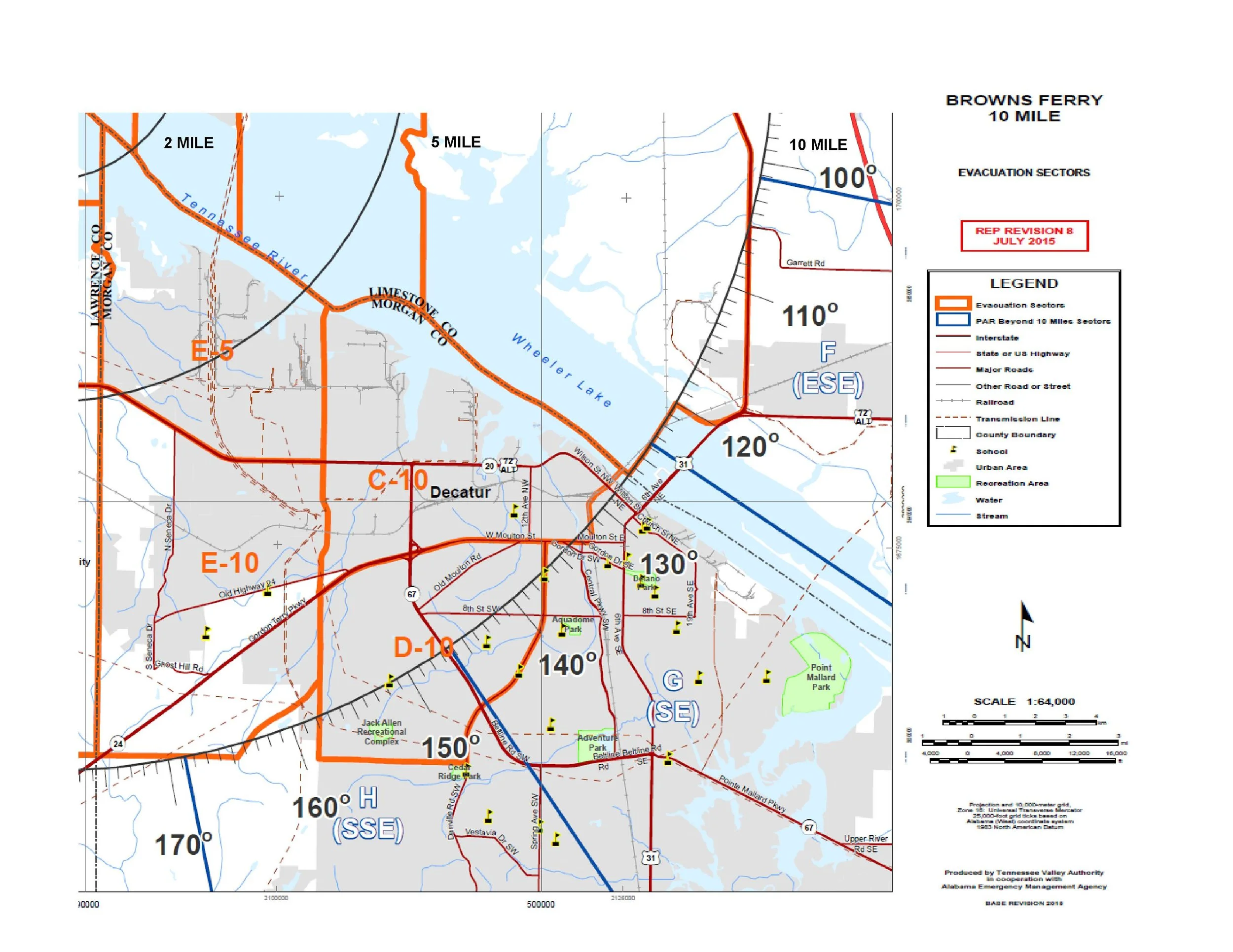
Sector Map
Know what your Emergency Planning Zone sector is. These zones are classified by distance from the Browns Ferry Nuclear Power Plant - two-mile zone, five-mile zone and ten-mile zone. Portions of Morgan County fall within the five and ten mile zones. Click the button below to find your zone.

Evacuation Routes
The evacuation routes for Browns Ferry are tied to the emergency planning sectors. Check your Emergency Planning Zone (above) to determine your evacuation route. Traffic may also be directed by emergency workers. Once you have started your evacuation, proceed to the nearest reception center and register as an evacuee. Click the button below to find out more information on the evacuation routes.
If you are asked to leave the area (evacuate)
What should you do if you are asked to evacuate your home if an event occurs at Browns Ferry Nuclear Power Plant? Click the button below for recommendations on what you should do if asked to leave. Please familiarize yourself with these actions if you live within the 10-mile Emergency Planning Zone (EPZ)

Reception Center
A pre-designated facility located outside the plume exposure pathway emergency planning zone (at a minimum 15 miles from the nuclear power plant) at which the evacuated public can register; receive radiation monitoring and decontamination; receive assistance in contacting others; receive directions to congregate care centers; reunite with others; and receive general information.